
Alabat Rural Health Unit Map | Alabat Satellite Map
placemark category: buildinggeographical location: Quezon, Region 4, Philippines, Asia
geographical coordinates: 14° 5' 29" North, 122° 1' 15" East
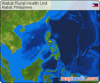
Alabat Rural Health Unit
near Alabat Island District Hospital and macapagal Gymnasium
detailed map of Alabat Rural Health Unit in Alabat area
![]() Welcome to the Alabat Rural Health Unit google satellite map! This building placemark is situated in Quezon, Region 4, Philippines and its geographical coordinates are 14° 5' 29" North, 122° 1' 15" East. Original name (with diacritics) of the place is Alabat. See Alabat Rural Health Unit photos and images from satellite below, explore the aerial photographs of Alabat Rural Health Unit in Alabat area.
Welcome to the Alabat Rural Health Unit google satellite map! This building placemark is situated in Quezon, Region 4, Philippines and its geographical coordinates are 14° 5' 29" North, 122° 1' 15" East. Original name (with diacritics) of the place is Alabat. See Alabat Rural Health Unit photos and images from satellite below, explore the aerial photographs of Alabat Rural Health Unit in Alabat area.
Do you like this map? Link to it!
Register at Alabat or add new placemark for Alabat.
Get your personal map homepage and much more for free.
Alabat hotel reservations
Book hotel near Alabat Rural Health Unit online and save money
- Hotels near Alabat Rural Health Unit »
- Browse & Book hotels in Philippines »
- Alabat hotels – sortable list of all Alabat hotels »
Alabat hotels: low rates, no booking fees, no cancellation fees.
![]() Maplandia.com in partnership with Booking.com offers highly competitive rates for all types of hotels in Alabat, from affordable family hotels to the most luxurious ones. Booking.com, being established in 1996, is longtime Europe’s leader in online hotel reservations.
Maplandia.com in partnership with Booking.com offers highly competitive rates for all types of hotels in Alabat, from affordable family hotels to the most luxurious ones. Booking.com, being established in 1996, is longtime Europe’s leader in online hotel reservations.
At Maplandia.com you won't be charged any booking fees, cancellation fees, or administration fees – the reservation service is free of charge. The reservation system is secure and your personal information and credit card is encrypted.
We have put together also a carefully selected list of recommended hotels in Alabat, only hotels with the highest level of guest satisfaction are included. Many photos and unbiased hotel reviews written by real guests are provided to help you make your booking decision. Luxury (including 5 star hotels and 4 star hotels) and cheap Alabat hotels (with best discount rates and up-to-date hotel deals) are both available in separate lists. Always bear in mind that with Maplandia.com and Booking.com the best price is guaranteed!
Alabat car rental
Compare Alabat car rental offers of 500+ suppliers
![]() We search over 500 approved car hire suppliers to find you the very best Alabat rental prices available. You can compare offers from leading car hire suppliers like Avis, Europcar, Sixt or Thrifty as well as budget rental deals from Holiday Autos, Budget, Economy, EasyCar, or 121 carhire. Choose Alabat car hire supplier according to your preferences. The booking process is secured and is made as simple as possible. You don't have to browse through several websites and compare prices to find cheap car rental in Alabat — we will do it for you!
We search over 500 approved car hire suppliers to find you the very best Alabat rental prices available. You can compare offers from leading car hire suppliers like Avis, Europcar, Sixt or Thrifty as well as budget rental deals from Holiday Autos, Budget, Economy, EasyCar, or 121 carhire. Choose Alabat car hire supplier according to your preferences. The booking process is secured and is made as simple as possible. You don't have to browse through several websites and compare prices to find cheap car rental in Alabat — we will do it for you!
Flights from airports close to Alabat
Search and compare flights
- Flights to nearby airports to Alabat »
- Overview of flights to and from Philippines »
- Flights search »
Compare prices on flights to and from the closest airports to Alabat Rural Health Unit. We search through offers of more than 600 airlines and travel agents. When you find a deal you want, we provide link to the airline or travel agent to make your booking directly with them. No middlemen. No added fees. You always get the lowest price.
Alabat Rural Health Unit 3D map in Google Earth
3D map of Alabat Rural Health Unit in Alabat
![]() You can also dive right into Alabat Rural Health Unit on unique 3D satellite map provided by Google Earth. With new GoogLe Earth plugin you can enjoy the interactive Alabat Rural Health Unit 3D map within your web browser.
You can also dive right into Alabat Rural Health Unit on unique 3D satellite map provided by Google Earth. With new GoogLe Earth plugin you can enjoy the interactive Alabat Rural Health Unit 3D map within your web browser.
Alabat Rural Health Unit satellite map link options
link to this page:
There are several options how to link to this map page — see the pretty images below. Please choose one and simply copy & paste mentioned HTML code into your page source code. Thank you for all links!
Alabat Rural Health Unit satellite map text link
Alabat Rural Health Unit satellite map micro bar image link
Alabat Rural Health Unit satellite map button image link
Alabat Rural Health Unit satellite map rectangle image link

Alabat Rural Health Unit satellite map large rectangle image link
large Alabat Rural Health Unit satellite map link
latest placemarks
- Alternative Cleaning Ltd in Aldershot, Hampshire County, South East, England, United Kingdom
- Alternative Cleaning Limited in Aldershot, Hampshire County, South East, England, United Kingdom
- National Review illumishare Gehlert in Aschaffenburg, Aschaffenburg, Unterfranken, Bayern, Germany
- Diamond Cleaning Services in Etobicoke, Toronto Metropolitan Municipality, Ontario, Canada
- Roof Repairs Perth in Perth, Cambridge, Western Australia, Australia
random google map locations
Maplandia.com is not sponsored by or affiliated with Google.
- Copyright © 2005–2016 maplandia.com. All rights reserved.
- news
- faq
- contact us
- RSS
- XHTML & CSS